The organizer publishes a 2026 course PDF, map image and kilometre elevation chart.
Official course description ↗Course intelligence · JAL Honolulu Marathon 2026
Honolulu Marathon course, aid stations and toilets
Read the course visually first—Route, Terrain, Checkpoints and Replay—then turn the verified service points into an ETA, fueling, toilet and refill plan.
Course Cinema / Terrain Lab
Read the course with your eyes—not another wall of text.
Organizer route assets, elevation evidence, checkpoints and official replay are separated into visual modes. Nothing is drawn as “3D terrain” unless an official asset supports it.
Reference edition2026 official mapJAL Honolulu Marathon 2026
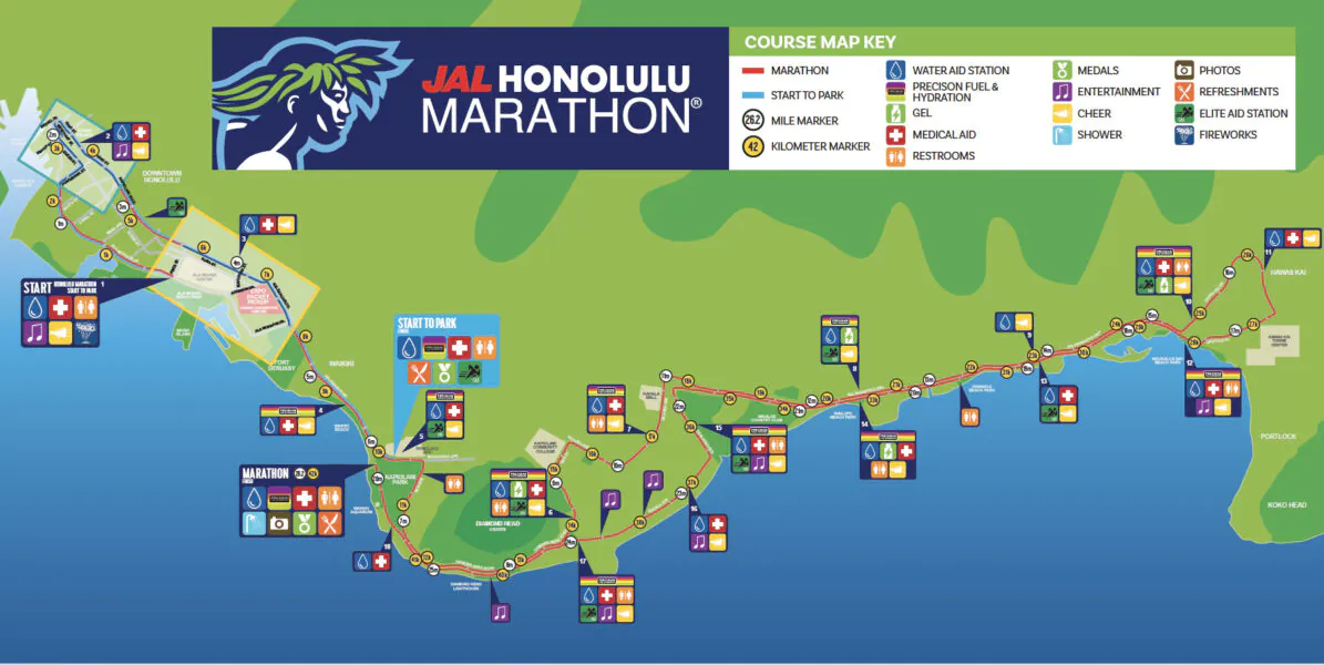
Official route
Official 2026 Honolulu Marathon course map
Use this visual for orientation; use the verified service explorer below for aid / toilet decisions.
Organizer course source ↗
Segment surface material is not specified point by point on the organizer page, so Race Guide keeps it unknown.
Official course description ↗Ala Moana BoulevardOfficial start area
Official courseUse the map to plan fuel and spectating
Kapiolani ParkFinish and clothing check area
Structured service points below4
Use the filters and ETA board below to turn these course points into a fueling / toilet / timing plan.
Learn the rhythm
2025 race replay
Play the organizer-linked 2025 YouTube playlist and keep the official result provider one click away.
Organizer-linked 2025 results ↗Interactive course services
Know what is available before you need it.
The organizer confirms 16 course aid stations with water, sports drink and medical support; gels are around Miles 9, 12, 15 and 20.
Race Day ETA mode
Tap a finish target. See the whole course in elapsed time.
No form and no personal data. This is an even-pace reference that turns course services into a practical race-day clock.
Target4:005:41 /km · 9:09 /mi
Use it as a reference, not a prediction: terrain, congestion, toilet stops, fueling and your actual start delay can shift arrival times. RaceZip does not convert an even-pace chart into a promise.
Mile 9
Organizer FAQ lists gel around this mile; exact placement may vary by up to roughly half a mile.
Verify this checkpoint ↗Mile 12
Organizer FAQ lists gel around this mile; exact placement may vary by up to roughly half a mile.
Verify this checkpoint ↗Mile 15
Organizer FAQ lists gel around this mile; exact placement may vary by up to roughly half a mile.
Verify this checkpoint ↗Mile 20
Organizer FAQ lists gel around this mile; exact placement may vary by up to roughly half a mile.
Verify this checkpoint ↗Coverage boundary: The first aid station is around 2.5 miles and then roughly every 2–3 miles; because no exact station-by-station distance table is published, Race Guide does not invent the remaining positions.
3 organizer sources
How to use it
Turn course data into a race plan, not another wall of text.
Read Route / Terrain first
Load organizer interactive maps only when needed. If there is no separate verified elevation asset, RaceZip says so instead of drawing a decorative profile.
Then use ETA / services
Tap a finish target to turn checkpoint distance into elapsed time, then decide the water, gel, toilet and refill rhythm.
Re-check before race day
Organizers can change services close to the event. RaceZip preserves sources and coverage boundaries instead of presenting an old edition as current.